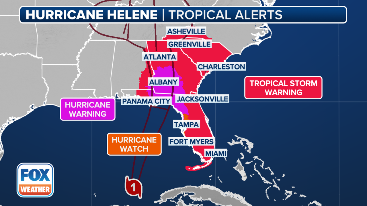
On Wednesday morning, Helene strengthened into a hurricane from a tropical storm. This week, it is predicted that Helene will make landfall on Florida's Gulf Coast as a major hurricane, most likely in the Big Bend region.
The National Hurricane Center reports that Hurricane Helene is still strengthening over the Gulf of Mexico and is heading northeast toward Florida with gusts as high as 85 mph.

Jamie Rhome, deputy director of the National Hurricane Center, stated on Wednesday night that the storm is expected to make landfall in northwest Florida late on Thursday and has the potential to strengthen into a significant Category 4 storm.
"You need to prepare for prolonged power outages ... significant downed trees ... you need to think about what you need to stay home for several days," Rhome stated. "Pick it up and finish tonight. Not the following day. This evening."
Hurricane Helene is forecast to make landfall in the Florida Panhandle on Thursday night, according to a map provided by the National Hurricane Center. The center of the forecast route is Tallahassee.
Based on two pressure systems driven by the Gulf of Mexico's record-warm water, the storm is intensifying and is expected to produce "life-threatening storm surge, damaging winds, and flooding rain to a large portion of Florida," the National Hurricane Center warned.
There are hurricane warnings in place between Mexico Beach, Florida, and the Anaclote River. There are also warnings in effect for certain areas of Mexico. There are storm surge warnings in effect for Tampa Bay and other areas of Florida. sections of Florida are under hurricane watch, and sections of Cuba and Florida are still under tropical storm warnings and watches. Nonetheless, the hurricane will still have an influence on places that are not in its direct path.
It's more complicated than just the cone and the center. Stephanie Abrams, a meteorologist for The Weather Channel, stated on Wednesday morning, "This is a large system with wide-reaching effects."
The storm's remnants are expected to move into Georgia and Alabama on Friday morning, crossing over Atlanta and Huntsville, before moving north through Tennessee and into the Midwest during the weekend.
On Thursday morning, strong winds are predicted to strike the Florida Panhandle; over the day, the storm is predicted to lessen as it moves toward Georgia. However, as the system proceeds inland, tropical storm-force winds could still be experienced in parts of the Southeast, including the Carolinas.
It is predicted that catastrophic storm surges would occur in many regions, particularly between Tampa and Panama City. Storm surges of between fifteen and twenty feet are possible along the coast from Carabelle to the Suwanee River. A surge of ten to fifteen feet might hit areas east and west of that section. Storm surge in the Tampa Bay area is expected to reach five to eight feet.
On Wednesday morning, Helene strengthened into a hurricane from a tropical storm. This week, it is predicted that Helene will make landfall on Florida's Gulf Coast as a major hurricane, most likely in the Big Bend region.
The National Hurricane Center reports that Hurricane Helene is still strengthening over the Gulf of Mexico and is heading northeast toward Florida with gusts as high as 85 mph.
Jamie Rhome, deputy director of the National Hurricane Center, stated on Wednesday night that the storm is expected to make landfall in northwest Florida late on Thursday and has the potential to strengthen into a significant Category 4 storm.
"You need to prepare for prolonged power outages ... significant downed trees ... you need to think about what you need to stay home for several days," Rhome stated. "Pick it up and finish tonight. Not the following day. This evening."
Hurricane Helene is forecast to make landfall in the Florida Panhandle on Thursday night, according to a map provided by the National Hurricane Center. The center of the forecast route is Tallahassee.
Based on two pressure systems driven by the Gulf of Mexico's record-warm water, the storm is intensifying and is expected to produce "life-threatening storm surge, damaging winds, and flooding rain to a large portion of Florida," the National Hurricane Center warned.
There are hurricane warnings in place between Mexico Beach, Florida, and the Anaclote River. There are also warnings in effect for certain areas of Mexico. There are storm surge warnings in effect for Tampa Bay and other areas of Florida. sections of Florida are under hurricane watch, and sections of Cuba and Florida are still under tropical storm warnings and watches. Nonetheless, the hurricane will still have an influence on places that are not in its direct path.
It's more complicated than just the cone and the center. Stephanie Abrams, a meteorologist for The Weather Channel, stated on Wednesday morning, "This is a large system with wide-reaching effects."
The storm's remnants are expected to move into Georgia and Alabama on Friday morning, crossing over Atlanta and Huntsville, before moving north through Tennessee and into the Midwest during the weekend.
On Thursday morning, strong winds are predicted to strike the Florida Panhandle; over the day, the storm is predicted to lessen as it moves toward Georgia. However, as the system proceeds inland, tropical storm-force winds could still be experienced in parts of the Southeast, including the Carolinas.
It is predicted that catastrophic storm surges would occur in many regions, particularly between Tampa and Panama City. Storm surges of between fifteen and twenty feet are possible along the coast from Carabelle to the Suwanee River. A surge of ten to fifteen feet might hit areas east and west of that section. Storm surge in the Tampa Bay area is expected to reach five to eight feet.